The best waterfalls near Gatlinburg are all within a 1.5 hours drive from the city, offering ways to cool down in the summer heat while enjoying the natural elements of the Great Smoky Mountains National Park.
If you’re looking for a break from the hustle of downtown Gatlinburg and Pigeon Forge, check out my picks for the best hikes near Gatlinburg with waterfalls.
6 Waterfalls near Gatlinburg
Laurel Falls
This post may contain affiliate links. Please see our disclosure.
Laurel Falls via Adobe Stock
The closest waterfall trail to Gatlinburg, Laurel Falls is one of the most popular hikes in the park. On any given day, you’ll see every generation of hikers enjoying the moderate 2.6-mile round-trip trail. Grab your gear and head there early to beat the crowd.
Each season offers a new perk to visiting Laurel Falls. Whether it’s the frozen falls of winter, wildflowers of spring, or cool down-dip of summer, Laurel Falls offers something for everyone.
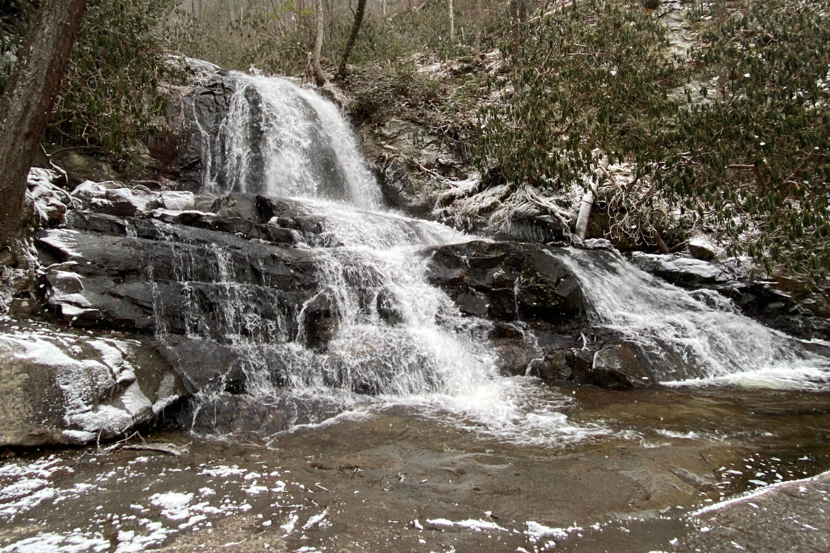
Laurel Falls in Winter, by Kylie Hubbard
To find the trailhead, drive 3.7 miles west on Little River Road from the Sugarlands Visitor Center. A parking area lines both sides of the street; Laurel Falls trailhead will be on the right and the Sugarland Mountain Trail opposite it.
Nestled in the Roaring Fork Motor Trail, which is open April 1-November 30 each year, the Rainbow Falls trail is easily one of the most popular hikes of the area, along with a hike not far down the trail, Grotto Falls. A 5.4-mile out and back hike, a trip to Rainbow Falls can be done in a day but isn’t for the fainthearted due to its steep grades and rocky trail.
Sitting roughly 80 feet above the rocks below, water flows from LeConte Creek over a ledge, and if the sun hits the water just right, a rainbow can be seen. Most of the water changes to mist before it can touch the rocks, but you’re guaranteed to see plenty of hikers making the same trek as you any time of year.
To find the trailhead, turn at light #8 onto Historic Nature Trail-Airport Road. Drive for about half a mile before hitting a confusing intersection. Stay right and continue straight, and you will hit the Rainbow Falls trailhead a little over 3 miles from the traffic light you turned at.
About 20 minutes from Gatlinburg, Baskins Creek Falls is one of the lesser-known waterfalls of the area. Continue on the Roaring Fork Motor Trail from the Rainbow Falls trailhead to find the short 3.2-mile round trip hike to the falls.
Although short, the hike is strenuous due to steep scramble paths when you get closer to the falls. The waterfall is worth the scramble, though!
To find the trailhead, travel to the Roaring Fork Motor Nature Trail. There’s a small parking area to the left after you’ve traveled almost 3 miles from the motor trail’s start; it’s just before the Jim Bales Place. The trailhead sits at the middle of the parking area.
Ramsey Cascades
Ramsey Cascades via Adobe StockThe highest of the Great Smoky Mountains’ major waterfalls, Ramsey Cascades is a must if you only have one day to hike. Not only does the hike feature the 100-foot waterfall, but you’ll also find old scenic growth, wildflowers in the spring, and cascading streams around every corner.
Even with a few steep sections, the hike is a moderate 8 mile out and back day hike. Make sure to wear your best shoes to navigate the rocks, roots, and slippery dirt.
To find the trailhead, turn at light #3 from US 441 in Gatlinburg to travel east for 5.9 miles on US 321 before turning right onto Greenbrier Rd (south). The road will change to gravel right past the ranger station, and at 3.1 miles the road turns left to cross Porters Creek. Another 1.5 miles down the road leads to the parking area.
Spruce Flat Falls
Spruce Flat Falls via Adobe Stock
One of the most scenic waterfalls in the national park, Spruce Flats Falls is often quiet and unknown to many Gatlinburg visitors. A 2-mile round trip hike, the waterfall has multiple drops, with the highest being about 40 feet high.
The trail is covered in rocks and roots but is a moderate hike that can be done in under 2 hours, depending on the time you spend at the falls. You can find the trail at the Great Smoky Mountains Institute at Tremont, an environmental education center.
To find the trailhead, travel to the Institute at Tremont by heading southwest from the Townsend Y towards Cades Cove. About 0.2 miles from the Y, you’ll find Tremont Road on the right. Follow the road for 2 miles to the institute on the left.
Abrams Falls
Abrams Falls, by Kylie Hubbard
Looking for the most voluminous falls in the park? Look no further than Abrams Falls in Cades Cove! Although the waterfalls only 20 feet from the pool of water below, the width of the falls gives the destination the greatest water volume. A 5 mile out and back hike, the moderate trail is littered with rocks, wildlife, and boot-packed dirt.
The hike follows Abrams Creek for almost the full 2.5 miles to the falls, and you can expect to see many more hikers on your hike. Consider getting to the trailhead early, or expect to fight traffic both on the Cades Cove Loop Road or on the trail. Cades Cove is open sunrise to sunset, and on Wednesdays from early May through September the loop is reserved for cyclists.
To find the trailhead, travel to Cades Cove Loop Road. From the start of the loop, drive 4.9 miles, and turn right onto a gravel road on the right. At the end of the road, you’ll find a parking area, and the trailhead starts at the north end.
Kylie Hubbard graduated from the University of Tennessee with a degree in journalism in December 2019 where she was the Editor-in-Chief of The Daily Beacon, and has worked with various organizations in Knoxville and Nashville, Tennessee through writing, design, communications and marketing. Kylie loves sharing stories, and spending time outdoors.